Mandatory evacuations, fast-moving flames, and conflicting acreage figures turned Santa Clarita’s Bike Fire into a stress test of public warning systems and trust.
Story Snapshot
- Officials ordered and later lifted evacuations as the Bike Fire threatened homes.
- Firefighters from multiple agencies used aircraft and ground crews to halt the spread.
- College of the Canyons opened as an evacuation shelter for displaced residents.
- News outlets reported different acreage totals, adding confusion for the public.
Evacuations Ordered As Fire Ignites Near Santa Clarita Homes
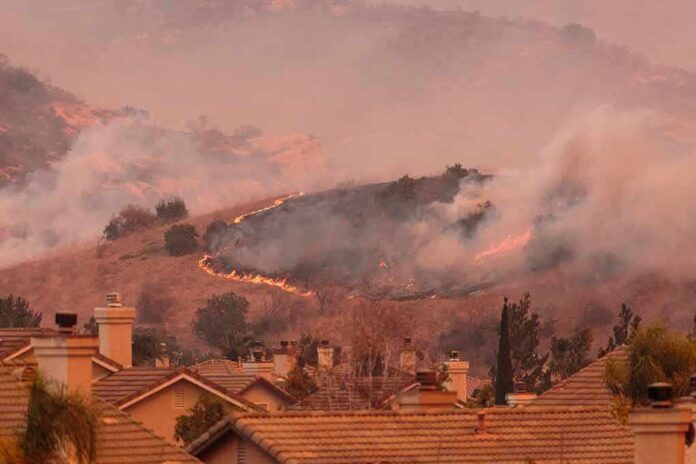
CAL FIRE recorded the Bike Fire starting on October 11, 2026, near Camdria Estates Lane and Ravenhill Road in Santa Clarita. Officials issued evacuation orders for zones including SCL-SULTUS, NADEU-A, SCL-SANDSOUTH-B, and later SCL-MACMILLAN as the fire advanced. Authorities also posted evacuation warnings for nearby communities to prepare people to leave if needed. These steps show a tiered approach designed to move the most at-risk residents first and alert neighbors as conditions changed.
Los Angeles County firefighters and the United States Forest Service worked together to protect homes and slow the fire. Aircraft supported crews on the ground, and the Angeles National Forest reported using two Super Scoopers to drop water on hot spots. The Los Angeles Times reported that the fire grew to about 170 acres at one stage and threatened homes, prompting a broad response across agencies. Officials urged residents to follow orders quickly to keep roads clear for engines and ambulances.
Shelters, Warnings, And The Path To Reopening Neighborhoods
Authorities opened an evacuation shelter at College of the Canyons, at 26455 Rockwell Canyon Road, to receive people leaving their homes. The shelter signaled that officials expected real displacement, not just short-term advisories. As conditions improved, CAL FIRE recorded that earlier evacuation orders were downgraded to advisories, and residents were allowed to return home that evening. This sequence—order, warn, then downgrade—matches standard wildfire practice as crews get the upper hand and direct threats ease.
Officials also posted evacuation warnings for SCL-NADEU-B, SCL-CRYSTALSPRINGS, SCL-WOODLAND, SCL-SANDSOUTH-A, SCL-FAIROAKSRANCH, SCL-MEDLEYRIDGE, and SCL-ROLLINGHILLS-B to give nearby areas time to get ready. Graduated alerts aim to reduce last-minute panic and traffic jams when minutes matter. Research on wildfire behavior and evacuation shows that many people wait to see flames before they act, which can tighten escape time. That pattern is one reason leaders sometimes move early with orders and warnings to save lives.
Acreage Discrepancies And Why Clear Messaging Matters
Different outlets reported different acreage totals for the Bike Fire, with some reports near 170 to 172 acres and others citing about 475 acres. These gaps likely reflect fast updates, shifting measurements, or different timing. But the effect is real for families watching from their phones. Mixed numbers can make people doubt the scale of danger or tune out alerts. Clear, plain language and a single, shared map can make warnings easier to follow during a chaotic afternoon.
FAST MOVING CALIFORNIA WILDFIRE FORCES EVACUATIONS
A rapidly spreading wildfire is threatening communities in Santa Clarita, California, forcing residents to evacuate as flames sweep through dry vegetation.
The fire broke out Sunday afternoon near Camdria Estates Lane and… pic.twitter.com/9n66Ee2fsb
— Michael Bradbury (@MrMBB333) October 12, 2026
CAL FIRE’s updates named cross streets and zones, while news stories used area names like Sand Canyon and Placerita Canyon. That split can confuse residents who do not know their zone code. A standard approach—zone name, common neighborhood label, and a simple map link—would help people know if they must leave now or simply prepare. The cause of the Bike Fire was not identified in the available records, and officials did not report confirmed injuries or structure losses in the retrieved material.
Sources:
nypost.com, fire.ca.gov, latimes.com, cbsnews.com, abc7.com